Title: South America. From Original Documents, including the survey by the officers of H.M. Ships Adventure and Beagle
Title: South America. From Original Documents, including the survey by the officers of H.M. Ships Adventure and Beagle
[EM BRANCO]
Details
[EM BRANCO]
001SK00124.jpg
Martha e Erico Stickel
Brasiliana > Martha e Erico Stickel > South America. From Original Documents, including the survey by the officers of H.M. Ships Adventure and Beagle
Gravura
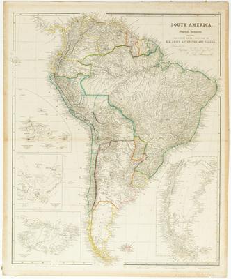
South America. From Original Documents, including the survey by the officers of H.M. Ships Adventure and Beagle
(Título original)
Mapa que representa a América do Sul
Rotogravura e aquarela sobre papel
62.5(height) x 52.2(width)(mancha)
67(height) x 55(width)(suporte)
64.7(height) x 54.5(width)(testemunho)
67(height) x 55(width)(suporte)
64.7(height) x 54.5(width)(testemunho)
Tooley, R.V. Maps and Map-Makers. B.T. Batsford Ltd. London. 1978
Moreland, Carl & Bannister, David. Antique maps. Third edition. Londres: Phaidon Press Limited, 1989.
Exemplar de 1842 in http://www.davidrumsey.com/maps831.html
Outro exemplar (edição 1844) in http://www.galapagos.to/MAPS.HTM
Exemplar da mesma edição (1839, Coleção American Philospphy Society) in http://www.amphilsoc.org/guides/rog/rogprintedmaps12.htm
This image is in the public domain and can be downloaded freely. Please cite the author's name followed by Acervo Instituto Moreira Salles. IMS is not responsible for any edits or uses that may defame the intellectual property of the image.
John Arrowsmith / Coleção Martha e Erico Stickel / Acervo Instituto Moreira Salles