Title: (Hemisfério terrestre meridional, delineado segundo as últimas observações das viagens, e novas descobertas do Capitão Cook)
Title: (Hemisfério terrestre meridional, delineado segundo as últimas observações das viagens, e novas descobertas do Capitão Cook)
[EM BRANCO]
Details
[EM BRANCO]
001SK00129.jpg
Martha e Erico Stickel
Brasiliana > Martha e Erico Stickel > (Hemisfério terrestre meridional, delineado segundo as últimas observações das viagens, e novas descobertas do Capitão Cook)
Gravura
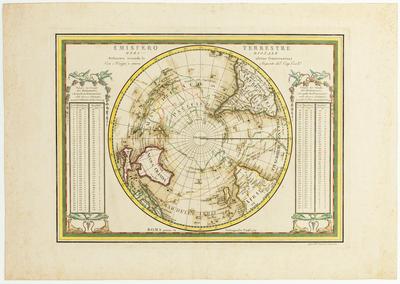
Emisfero Terrestre Meridionale Delineato secondo le ultime Osservazioni Con i Viaggi, e nuove Scoperte del Cap. Cook
(Título original)
(Hemisfério terrestre meridional, delineado segundo as últimas observações das viagens, e novas descobertas do Capitão Cook)
(Título atribuído)
Mapa que representa o Hemisfério Sul
Água-forte, buril, lápis de cor e aquarela sobre papel
33.1(height) x 45.8(width)(mancha)
43.7(height) x 62.7(width)(suporte)
34.8(height) x 47.6(width)(testemunho)
43.7(height) x 62.7(width)(suporte)
34.8(height) x 47.6(width)(testemunho)
Moreland, Carl & Bannister, David. Antique maps. Third edition. Londres: Phaidon Press Limited, 1989. Pg. 73.
Outro exemplar (mesma edição?) in http://catalogue.nla.gov.au/Record/2575560
O mesmo exemplar é melhor detalhado in http://digmap1.ist.utl.pt:8080/records/OaiNla/html/oai_nla.gov.au_nla.map-t287.html
Outro exemplar (mesma edição?) in http://catalogue.nla.gov.au/Record/2575560
O mesmo exemplar é melhor detalhado in http://digmap1.ist.utl.pt:8080/records/OaiNla/html/oai_nla.gov.au_nla.map-t287.html
This image is in the public domain and can be downloaded freely. Please cite the author's name followed by Acervo Instituto Moreira Salles. IMS is not responsible for any edits or uses that may defame the intellectual property of the image.
Giovanni Maria Casini / Coleção Martha e Erico Stickel / Acervo Instituto Moreira Salles