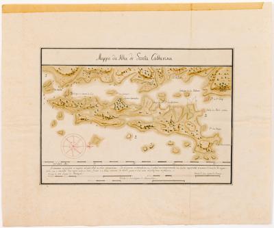
Title: Mappa da Ilha de Santa Catherina
Title: Mappa da Ilha de Santa Catherina
[EM BRANCO]
Details
[EM BRANCO]
001SK00152.jpg
Martha e Erico Stickel
Brasiliana > Martha e Erico Stickel > Mappa da Ilha de Santa Catherina
Desenho
Mappa da Ilha de Santa Catherina
(Título original)
Desconhecido (Autoria)
Nanquim e aquarela sobre papel
20(height) x 28.2(width)(mancha)
32.5(height) x 39.2(width)(suporte)
32.5(height) x 39.2(width)(suporte)
Reproduzido em preto e branco no catálogo "Image du Brésil", da Exposição Internacional de Bruxelas (1973), como "Map of Santa Catarina" (no capítulo "De XIXe Eeuw: De Vrije Natie"); reproduzido também em "Uma pequena biblioteca particular: subsídios para o estudo da iconografia no Brasil" (2004), de Erico Stickel, à pg. 628.
This image is in the public domain and can be downloaded freely. Please cite the author's name followed by Acervo Instituto Moreira Salles. IMS is not responsible for any edits or uses that may defame the intellectual property of the image.
Autor Desconhecido / Coleção Martha e Erico Stickel / Acervo Instituto Moreira Salles